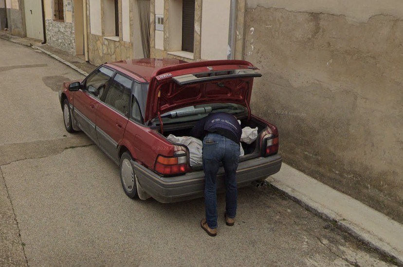
A Google Street View image contributed to solving a missing person case in Spain, as reported by the BBC and The New York Times. The image, which remains available on Street View, depicts what seems to be an individual placing a large object into the trunk of a car, according to Gizmodo. Another image, highlighted by the BBC, shows someone moving “a large white bundle in a wheelbarrow.”
The Spanish National Police confirmed the discovery of partial human remains linked to the missing person buried in a cemetery in Soria province. Advanced forensic and technical methods were employed to locate the remains. The investigation relied on various pieces of evidence, including imagery from a location search application, though this evidence was not the sole factor in cracking the case.
While the police press release did not explicitly name the application, a spokesperson for the Spanish National Police later confirmed to The New York Times that the images originated from Google Maps. However, the spokesperson clarified, “The image was not the key to solving the case.”

The case revolved around the disappearance of a 33-year-old man who went missing last year while visiting a partner in Tajueco, a town in Soria. Following months of investigation, police arrested a woman and her ex-partner in November, both of whom are linked to the crime. Details of the suspects’ motives and involvement remain under investigation.
This is not the first instance where Google Maps has been instrumental in criminal investigations. In 2022, Italian authorities used Street View to track down the location of a mafia fugitive who had evaded capture for years.
In the current case, the Street View images served as part of a broader investigative toolkit that included technical advancements and traditional police work. This highlights the increasing role of digital mapping and surveillance technologies in modern law enforcement. While the use of such tools has drawn praise for aiding in the resolution of complex cases, it also raises questions about privacy and the ethical implications of relying on publicly available imagery for criminal investigations.
The Spanish National Police’s use of Google Maps imagery exemplifies how technology can complement traditional investigative methods, helping authorities locate critical evidence and track down suspects. However, officials have emphasized that while the imagery provided clues, it was only one piece of the puzzle in solving the crime.
As technology continues to evolve, tools like Google Maps and Street View are likely to play a growing role in law enforcement efforts worldwide. These tools not only aid in solving crimes but also underscore the need for robust discussions about privacy, ethical considerations, and the balance between public safety and individual rights.
